
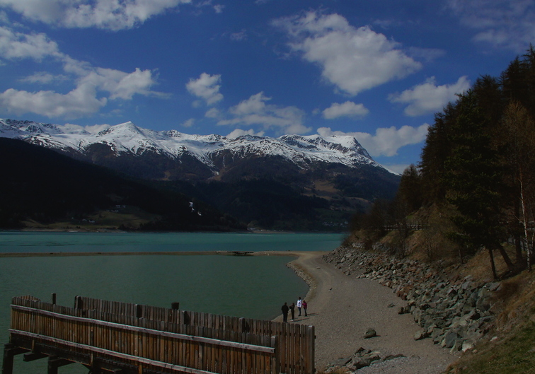
Lake Resia / Reschensee
|
|
|
Lake Resia / Reschensee
|
|
About 23
Just In
Discover the world from a different angle.
Here's a crop of the latest photos from the around the world. |
Popular photos right now    |
6 comments so far...
Angesichts dieses wirklich sehr einfachen Passes fragt man sich, was der Ötzi nur wenige km weiter östlich, allerdings 1500m weiter oben gemacht hat. Warum ist er nicht hier herüber gegangen? (Eine mögliche Antwort könnte lauten: er wollte gar nicht rüber.)
Jedenfalls als wir mal in Vernagt Uraub gemacht haben, erzaehlte uns die Hauswirtin, Menschen aus ihren Dorf hatten von je her eigentlich zum Oetztal gehoert statt zum unteren Schnalstal, und wenn man da schon mal war, war es sehr viel leichter noch etwas zum Similaunpass rauf und dann runter ins Oetztal zu wandern als ins Etschtal abzusteigen. Erst mit der modernen Strasse wurde es so, das man Waren einfacher von der nun italienischen Seite raufbringt, denn der Steig vom Etschtal her war noch zur Zeit ihrer Grosseltern streckenweise ziemlich schlecht und risikoreich, aber auf beiden Seiten war das Habsburger Reich, also wars Grenztechnisch egal. Die sind also immer relativ nahe beim Oetzi vorbeigegangen... aber natuerlich zwischen 3300 BC und der Zeit der Familienueberlieferung heutiger Alteningesessener kann sehr viel passiert sein, vorallem Unterspuelungen, Hangrutsche und so Sachen. Vieleicht war der Aufstieg in der Steinzeit ja sehr viel leichter als zu der Zeit als Karthaus von den Moenchen besiedelt wurde und das ganze eine echt gute Abkuerzung irgendwo hin...
I would actually crop out the bridge & people to make the shot more appealing & compositionally attractive -- I don't think the people add anything to the shot and the bridge/dock ruin the balance and it too much of a focal pt. due to its position... Hope you don't mind my saying so...
I guess the water level of the main lake is somewhat low, but the one of the pond protecting the submeged tower is not, unless it is planed to make the nice walkway around the sunken village vanish again. It was unpaved but made nicely all level with a bridge at the outflow, and at the inside close enough to the surface, and rather popular for the generally low time of the year, most people parking at the site went all around over it. There is little on this touristic features and anything post tower renovation online in german or english, only a lot of pages on the sad old story of the forced flodding in 1950. My command of modern italian language is very bad so I can only research what is written in languages I understand.
Fascinating find =)
By the way, you might find this link interesting.... Even features a photo prior to the flooding... And also, a photo of the remaining tower showing where the water line should be.... Amazing difference! I thought I remembered that lake being much deeper than in your photos, but was amazed by just how much -- the shoreline should be about halfway up those protective rocks! And that sandy path through the water shouldn't be there at all.... That water level is VERY low.
Anyway... Takes nothing away from the beauty of the area or the quality of your photo(s).
Two facts I know for sure.
- Lake Resia fishing is as good as non-existent. It is very cold up there and long frozen in spring, and closed off for maximum energy winning without any fish stairs for migrating trouts.
- When the village was cleared of the people, all buildings got torn down but the church tower. The corpses in the coffins and their grave stones where all collected from the graveyard in a huge efford and saved all uphill overlooking the sunken village, some other stuff good enough and easy to retrieve was salvaged by the owners, and the manure pits got of course scraped out as good as possible as not to endanger the people downstream of the dam, but what was left afterwards of it all including the church nave was leveled with heavy equipment.
Down there is no intriguing ruin lanscape with huge fish ala swiss chalet atlantis. There is nothing around the tower but rubble and clear icecold water. :o(